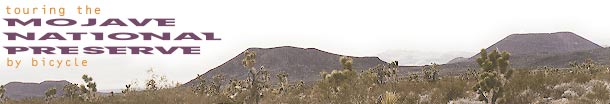
 DISTANCE: 57.7 miles
AVERAGE SPEED: 9.1 mph
ELEVATION: 3000 feet to 5000 feet to 4000 feet to 5600 feet
I'm never great at getting up early and hitting the road. Furthermore, I've developed an aversion to packing up. Maybe it's because
this is my first bike tour and I haven't developed an efficient way of doing it yet. I wonder if having top-loading panniers complicates matters slightly. I
occasionally find myself emptying most of a pannier just to get to something at the bottom. This is partly poor planning on my part, but one can't foresee
everything. I'm sure side-loading panniers have their own drawbacks.
10:30 a.m and I am finally leaving Nipton. The sun is hovering in another perfect blue sky decorated with a few clouds. It's warm
t-shirt weather, but there is still a hint of cool in the air. Cycling weather doesn't get any better than this.
Today, I'm off to see the unseen again, but I've diligently studied my maps and have read a lot about where I'm going. I hope to
make it to the Mid Hills campground up at 5600 feet. First, I have to climb to 5000 feet (here at Nipton, I'm at about 3000 feet), and then drop down to 4000
feet before the final climb to 5600. If I don't make it in time, I can always camp at Grotto Hills off Cedar Canyon Road.
The most direct route from Nipton to the beginning of my climb at the base of the New York Mountains is a dirt road along the
railway tracks. It's essentially the southbound extension of the Nipton-Desert Road I rode yesterday. It looks rough, so I'm not going to try it. I'm more than
willing to ride a few extra miles along the paved roads for speed and to avoid potentially difficult riding conditions.
From Nipton, I glide down the barely perceptible downhill for a couple of miles to the absolute bottom of Ivanpah Valley. Then I
pedal easily a few miles to the junction of Ivanpah Road. This valley is wide open, so the roads look like they go on forever as they carve their lines into
the landscape.
At the Ivanpah Road junction, I pull over for a few slugs of water and to take photos. Just as I'm ready to ride away, I go to brush
off some small leaves that are adhering to my front tire. Oops, these leaves are small knobby thorns from some hostile plant. And dozens of them have attached
themselves to my rear tire as well. I must have just run over these, but I look around and don't see any on the ground. I meticulously brush them all off using
a small twig, but I'm afraid that some residual broken thorns have remained in my tires, waiting to cause a puncture the moment I hit the road. I think I am
hearing a small hiss of air, but I hope I'm just imagining it. The sound stops. If it was real, maybe the guilty thorn has simply moved enough to plug the
puncture it created.
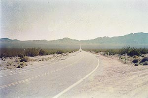 LOOKING BACK ON IVANPAH ROAD
View northbound toward Morning Star Mine Road and Nipton Road
Trying not to think about my tires, I cruise down Ivanpah Road, across the valley and toward the New York Mountains. In this
expansive desert vista, the road's gradual, straight-ahead rise out of the valley to the base of the real hills beyond looks frighteningly vertical. I'm not
expecting this from my maps. I continue and begin to understand the illusion; it's not steep at all. In fact, I'm really enjoying this pleasant, contemplative
stretch, which is not a surprise steep segment after all.
I pass Ivanpah, which is just a handful of buildings by the railway tracks with no services. Now the road begins its gentle crawl up
into the mountains. After a couple more miles, the pavement ends abruptly and a sign points this out to me in case I haven't noticed. It's a perfect occasion
to stop for a few gulps of water and to pump up that front tire that's has sadly lost a bit of air. Arrrgh.
I get back on the saddle and start riding up the wide dirt road. It's a little rough, but after yesterday's ride on the
Nipton-Desert Road, this is great. It reminds me of the fire roads in the hills around San Jose which are used as bicycle trails, but wider. The best part is
that the uphill is less steep than I anticipated. As I wind up into the New York Mountains, the valley panorama below starts to hide behind hilltops and soon
it is just another memory. The road slithers softly on upward, meandering between hills without reaching the mountains' highest points.
I discover the two-house settlement of Barnwell nestled in the hills at 4800 feet. No obvious, dramatic drop down into "the other
side of the mountain " presents itself yet, so I check my map and learn that I need to rise another 100 feet or so first. After another mile or so of this
highland landscape, the road finally begins its slow downhill course and starts serving up beautiful views of the Piute Range to the east. As I pick up speed,
I find myself frequently riding down the centre and on the wrong side of the road. Anything to avoid bumps and the sandy shoulders! Luckily, I only pass a
couple of oncoming cars.
After 11 miles of blissful, slow downhill that passes far too quickly, I reach the junction of Cedar Canyon Road and turn right
(west). I'm down at 4100 feet now and have 20 miles to go to reach the Mid Hills campground. In my mind, that's not too far, but I still have 1500 feet of
climbing ahead of me as well. Joshua trees and cholla cactus decorate this landscape whose serenity is increased by the postcard, late-afternoon sun.
After a mile on Cedar Canyon Road, I spot a hand-made sign for the road to Grotto Hills (aka Guirado Hills). I could head a couple
of miles up that dirt road to an informal camp site, but I don't feel ready to call it a day just yet. I'm still excited about visiting Mid Hills campground
after having heard several times from folks that I'll really like it. I still have two 1.5-litre water bottles remaining, so I could sleep over at waterless
Grotto Hills and still have enough until tomorrow. However, knowing that there is water up at Mid Hills inspires my confidence and pulls me onward.
My front tire has been slowly losing air all day. I'm a mile past the Grotto Hills turn-off and I realize that I have no choice but
to pull over and pump it up. Figuring I might as well deal with reality, I decide to patch the tube rather than just pump it up. My first patch doesn't seal
completely, so I redo it. I usually get irritated when doing repairs, but I'm proud of my patience when I realize that I'm ready to go in about 20 minutes. I
hate my slow-poke mini-pump which requires so much effort! Two cars pass me during this time (a lot of traffic!) and one friendly person stops to make sure I'm
not stranded. The sunset isn't lasting as long as I was hoping, so I mount my rear blinking light and rechargeable front headlight before hitting the road.
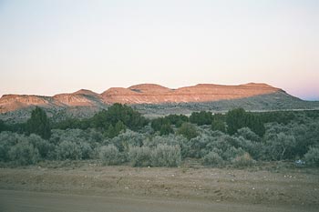 SUNSET ON CEDAR CANYON ROAD
Looking north to the New York Mountains
Almost instantly, it is night, except for a warm glow behind the mountains. I trudge through
the darkness at about 6 miles per hour. The sand-dusted road doesn't look to be uphill, but
it is. Furthermore, the sand and washboard texture is cutting down immensely on my speed. It
could also be that I'm simply getting tired after 37 miles, but I refuse to think about that.
After a few more miles, my rechargeable battery is waning far more quickly than expected and my headlight dims. The only way to
conserve the miniscule amount of power left in the battery (for what, I'm not sure) is to turn off the headlight. Hmmm...
My new, zero-light situation proves to be exhilarating. On this clear and moonless night, the sky is salted with more stars than
I've ever seen. The stingy starlight illuminates only enough for me to discern where the road is and where it is not. Slowly bumping my way upward, I randomly
slip in sand patches and then rattle on the washboard road surface. Each time my wheels make contact with one of these undesirable surfaces, I swerve
defensively, instinctively, but am unable to see what I am swerving toward—will it be better or worse? I almost veer off the road several times by
accident. So far, I haven't fallen, but I have had to dismount my bike a few times upon losing all traction in the sand.
I still have at least 10 miles to go in this beautiful, unexpected solitude. This must be hard work because time seems to be passing
slowly. My obligatory steering is constant, sudden, and very weighted-down, lending new meaning to the expression "feel the road." My arms are tired. I have
never before attempted to drive blindfolded, but I now have a feeling for what such an exercise in perception would be like. Not a single car has passed me yet
in this darkness.
I'm somewhere around Government Holes, I think, when I realize that the air has become substantially cooler. Of course, it is
evening, but I'm also at a much higher elevation than I was this morning. Most intriguing at this spot are the distinct warm and cool breezes that alternately
puff past. I pull over and hastily put on a sweat shirt. I am still in my short pants, but I'm too preoccupied to change. Short pants will be tolerable for a
little longer, I hope, since I have been pedaling uphill in low gear and am still almost sweating despite the cool air.
I've been cranking along for quite a while now. I'm now wondering if I could possibly have missed the Black Canyon Road turn-off
that I need to take to get to the Mid Hills campground. I have not started descending the other side of the mountain yet, nor do I intend to, so this is a good
sign. I just hope the road I'm looking for won't be invisible.
Finally, after another mile or so, my worries are quashed when I perceive a sign on the side of the road. To read it, I turn on my
headlight and futilely aim its dead beam at the sign. It really doesn't help, but I can make out that this is Black Canyon Road. Yippie! I try to turn, but
slip in the sand. I get off the 10-ton bike and walk a couple hundred feet before I can get back on. I am suddenly aware that I am totally exhausted,
hungry, and starting to get cold.
This segment of Black Canyon Road is heavily washboarded and sandy as well. Did I actually expect anything else? It's also a bit
steeper than the Cedar Canyon Road that I just left behind. I continue navigating my invisible obstacle course, which is becoming increasingly surreal. In this
real-life, virtual-reality game, all I know is that I am uncontrollably steering a wheel that is very heavy, and I can't stop. This will never end.
After two miles of this psychologically demanding climb (which would have been relatively easy under other circumstances), I reach
another sign that I can barely read. Yes, my next turn-off: Wild Horse Canyon Road. Two miles to the campground entrance, it annnounces in the dark. I'm
starting to feel like I won't make it, but I know full well that "of course I'll make it!" There's no possible way I could "not make it." Patience is a virtue,
but I'm starving... it's only two more miles!
It might be a good thing that I can't see this road. The washboard texture seems more intense than anything I've been on today.
Surface gravel on some of the sandiest sections is offering a new version of slipperiness for me to experience. Three short, but distinctly steeper, hills
challenge my legs. Each feels progressively more difficult. At least I'm still lucid enough to know that the road really isn't as bad as it seems and that I've
simply overextended myself.
Oh look! The campground entrance road! It is, isn't it? I've become so impatient that the final quarter-mile on the entrance road
feels like two more miles. I truly arrive when I detect an entrance bulletin board, but it's too dark for me to read anything on it. My headlight battery is
100% burned out.
Now all I want is a camp site, fast. On my left, I pick out the outline of a parked truck with a trailer, so I look for the next
available space. Any site would do, but even in this state of laziness, I'm still hoping to avoid camping too close to someone else, especially a noisy
vehicle. I see a small post bearing the number three, but in the dark I can't tell if I'm looking at a camp site or just a parking space. I lay down my bike
and peer into the scattered pinion pine and juniper trees (yes, there are small trees in the Mojave Desert up at 5600 feet!). Lo and behold, I decipher a
picnic table and fire ring!
I'm ecstatic! I drag my bike from the parking space into the camp site and hastily decide where I will set up the tent. First, I
unpack my panniers enough to get my flashlight, which I keep padded in the middle of a folded-up spare tire. I walk back to the bulletin board at the
campground entrance and shine my flashlight on it to learn what I am expected to do with regards to paying fees. I plan on sleeping in tomorrow and don't want
anyone to bother me! The thermometer at the bulletin board reads 3°C (39°F). No wonder it felt rather chilly on the way here!
In a final gesture of efficiency, I boil water, pour it into a Natural High instant-meal packet and go about setting up the tent
while the meal-for-two-in-a-bag steeps. Instant orange chicken and rice never tasted so good!
All I want to do now is go to bed, and it's only 9 p.m.! At 57.7 miles this wasn't the longest ride I have ever done, but it may
have been the most taxing. Whatever, it was a "breakthrough experience," as some self-improvement philosophies might describe it, that pushed me to new
limits.